Greetings from home, everyone!
I've just spent four wonderful days sightseeing in Sydney, and am now home for a real break until I return to campus to begin my junior year. What an amazing summer this has been! I do believe I have fallen for the Australian outback, and I am ultra-excited for my next opportunity to do field work, whenever that may be.
For my last update, I've written about some of the Aussies who have generously helped us in our research and assembled a list of entertaining (well, maybe only to us) quotes from the season. If you haven't been reading the blog regularly, that's okay--photographs are worth a thousand words, and I've compiled a bunch of my favorite photos from the season into the following slideshow/video. Enjoy! (*I highly recommend watching it in 720p HD, which you can choose by toggling the '360p' button on the lower bar.)
This post may mark the end of my summer blog, but it is not the end of my involvement in this project. This fall semester, I will continue my research by running carbon isotope analysis on the breccia samples collected from Saint Ronan and hopefully combine that data with the Trimble map to tell the story of the paleocanyon in a junior paper. Let's hope it all goes well!
So long and thanks for your support and for reading my blog! I've had a rewarding time, and I hope that it's been fun for you, too.
Christine

Thursday, August 18, 2011
Top 10 quotes from the field

"Both of my advisers have distinctive ways of holding their pants up."
"In Lord of the Rings, active tectonism is inherently evil."
"It seems that Marvolo, in his frustration, is shitting all over our cans."
"So when do we get to... to... Chippawhoopa?"
Friends of the Flinders

This summer, we've happened across all sorts of Aussies from all walks of life, and we have them to thank for having such a successful field season this year. Aside from the national park, the land we've been working on belongs to ranch owners who either acquired the property through government lease or own the land privately. It is under the auspices of these people that we are allowed to roam over the hills and through the woods to conduct some hardcore, rocking-awesome science. Generally, the people living around the Flinders Ranges are up to at least one of the following three things: ecotourism, farming, and coal mining.
Thursday, August 4, 2011
Day 48 Update
Hey there readers,
Greetings from Leigh Creek Elementary School, sadly for the last time. Alas, we are four days away from the end of the field season, and thus will not be returning to this quaint little town that has served us reliably as our resupply station. It's a bit ridiculous to think that we've been in the field for almost a month and a half now, though it definitely shows--the backs of our hands are about fifteen shades darker and look a bit like wrinkly bird feet.
Anyhow, since my last update, we:
we will return to the national park to measure a high-res section. Change of plans. We're heading back to Adelaide right this instant due to logistical complications. That's field work for you! Anyways, catch you all in a bit!
Christine
UPDATE (8/5): Due to my hasty choice of words, I may have freaked a bunch of you out. Sincerely sorry about that--Jon and I are quite well, with all ten fingers and toes present. We'll be continue to be in Adelaide for another day before heading back to the Flinders Ranges National Park to check out the Trezona limestone for some kicks and giggles (check out this old news story).
Greetings from Leigh Creek Elementary School, sadly for the last time. Alas, we are four days away from the end of the field season, and thus will not be returning to this quaint little town that has served us reliably as our resupply station. It's a bit ridiculous to think that we've been in the field for almost a month and a half now, though it definitely shows--the backs of our hands are about fifteen shades darker and look a bit like wrinkly bird feet.
Anyhow, since my last update, we:
- were caught in a very wet rain that delayed us for three days in Leigh Creek, but met the most positively kind Australians in the caravan park who treated us with fresh, homemade gourmet desert
- ran into more Beast trouble with a sheared bolt and missing nut on the rear left wheel, causing another day of delay
- finished mapping breccias within a 1-by-0.25 kilometer area at Saint Ronan (see this post)
- went ash hunting and scaled up a steep ridge of Wonoka (see this post)
- stumbled across two sun-bathing lizards and a bunch of baby emus
Christine
UPDATE (8/5): Due to my hasty choice of words, I may have freaked a bunch of you out. Sincerely sorry about that--Jon and I are quite well, with all ten fingers and toes present. We'll be continue to be in Adelaide for another day before heading back to the Flinders Ranges National Park to check out the Trezona limestone for some kicks and giggles (check out this old news story).
Mapping breccias

In an earlier post, I discussed how measuring a stratigraphic section can show us how rocks change from top to bottom. The end result is a one-dimensional, vertical chart of stacked boxes representing different rock types, but rocks rarely behave like perfect layers of a cake--more often than not, rocks change from side to side. For example, if we followed one rock layer down its length, it may change in lithology, sedimentary structure, or thickness, perhaps indicating changes in sea level at the time of deposition. To capture and understand this variability, we strive to create a geologic map.
In the last two places we've been, Jon and I have set out to create such a map, combining old methods with new fancy-schmancy technology. At Oodnapanicken, we split up and each mapped out the paleocanyon separately; Jon used the newly acquired Trimble technology while I mapped the old fashioned way, by hand with paper and pencil.
For me, old-school mapping is a throwback to my preschool days of scribbling within the newsprint sheets of connect-the-dots coloring books. In the same way that those numbered black dots form a picture (or some semblance of one), mapping provides a two-dimensional visualization of the outcrop and the interpretations made from it. The only difference is that we are not given the black dots on the page; those known values are exactly the things we seek out while mapping.
A day in photographs
The title says it all (though I should mention that these photos were taken in Saint Ronan, and that on this day, we did some reconnaissance and ash hunting). Enjoy!


Friday, July 15, 2011
Sedimentary structures and stuff
In an earlier post, I mentioned that Jon and I often search for sedimentary structures while measuring sections to get an idea of what the environment was like back when the rock-forming sediments were first deposited. This was a really vague and uninteresting statement, so I'd like to flesh it out and give you all a better look at some of the geology we're working with in Oz. Here's a little photo gallery of some of the most common geologic features we look at, and what they might tell us.
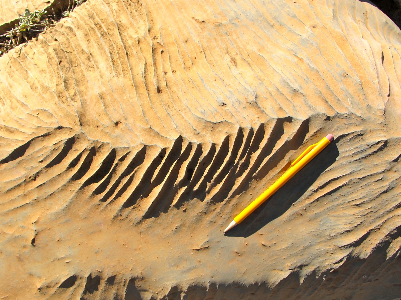
 Karst - We wouldn't be able to accomplish much science if we couldn't tell limestone (carbonate) apart from other types of rock. Since we cannot rely on the color of a rock as an indicator, we look for karst, which are a dead giveaway for carbonates. Karst are razor-edged 'ripples' that can be sharp enough to cut you at times. They are a "recent" feature, formed after our ocean sediments became rock and were uplifted into mountains, and after the carbonate sediments were exposed to rainfall. The slightly acidic rain is able to dissolve calcium carbonate, thus leaving behind the razor-sharp ridges that are a bane of weary geologists' butts.
Subscribe to:
Posts (Atom)